
The North Atlantic Arc Home
| September | /Octoberrrrrrrrrrrr |
| S | M | T | W | T | F | S |
| 18 | 19 | 20 | 21 | 22 | 23 | 24 |
| 25 | 26 | 27 | 28 | 29 | 30 | 1 |
| 2 | 3 | 4 | 5 | 6 | 7 | 8 |
| 9 | 10 | 11 | 12 | 13 | 14 | 15 |
| 16 | 17 |
 |
Friday 23
September 2005Up Against The Wall: Muckle FluggaThere is an older English couple in the B&B, and over breakfast we all discuss such Shetland issues as the all-time worst storms and the possibility of building a tunnel between Unst and Yell. I opine that one such tunnel in the Faroes, between Leirvik and Klaksvik, has eliminated the most beautiful ferry ride on earth, and is probably helping more people to move off the island it serves than to stay. Well, it's their island, I suppose. But I'll be surprised if anyone ponies up the cash to build a tunnel to serve 700 people. On the other hand, I can see housing estates going up outside Baltasound, so the island is perhaps growing. Apparently there are some residents commuting to Lerwick for work. It s hard for me to understand this as a lifestyle choice; Mainland is not exactly urban, nor is real estate in short supply. After poking around the island a bit, I head for the Herma Ness nature reserve. In the parking lot I find the English couple--or at least, the missus sitting in the car; the mister is just disappearing over the hill. She has (wisely) declined to join him, as the wind is blowing hard from the south, and the sky is not promising. Or rather, it is promising things we don't much care for. I get my shoes on and start on the trail. The stiff wind is at my back, which means of course that it will be in my face on the return. The trail splits about a half-mile up, forming a sort of misshapen backwards P. The last time I was here, I went straight up over the hill and tried to return around the loop, opposite to what is recommended; I got lost and almost sank forever into a bog. This time I take the western loop. About halfway to the cliffs, rain begins to fall. No, it isn't falling, it's being driven horizontally by the wind, and stings even through the clothing. If I had any sense, I would turn around, but I don't, and I feel compelled to make it to the end, as my entire trip would otherwise feel incomplete. So on I go, and in a matter of minutes, my trousers are soaked through. I am not wearing waterproof ones for two reasons: one, I don't own any; and two, they are strongly recommended against, as a stumble on the steep slopes above the cliffs could result in a fatal slide. My shoes are waterproof, but after a while, water wicks down my socks, and my feet are as wet as though I'd gone into the bog again. I reach the stunning cliffs and struggle to take a few photos. As I walk north along them, the prize comes into view: Muckle Flugga, the northernmost outpost of Britain, a jagged rock with a Stevenson lighthouse perched impossibly atop it. How could they possibly have built it without dropping the materials by helicopter? Despite the wind, it is very hazy, but I manage a couple photos, anyway. Before turning up the hill, I mark a waypoint on the GPS: N 60 50' 23.7", W 0 53' 43.7". It is a hard slog back, directly into the wall of wind; the worst of it is not being able to look where I'm going. Fortunately the trail is fairly clear the whole way. It's about a five-mile hike in all, not normally a very tough one, but I'm beat when I get back to the parking lot. I'm relieved to find Mr and Mrs English sitting in their car, as I did not see the fellow the whole way; he'd gone straight over the hill and straight back. They are waiting for me to get back safely, bless their kind hearts. No one else has been foolish enough to go out on Herma Ness today. Change my clothes and zip back to Lerwick via the two ferries. Near Weisdale, high on a hill with a lovely view (for it has now cleared), is a hotel with a bar serving cask ale, the only such in Shetland at the moment, I think. I stop and have a pint. Back in Lerwick, dinner is at the Queen's Hotel, and pints and drams are at the Lounge Bar. I will sleep well. Next |
 |
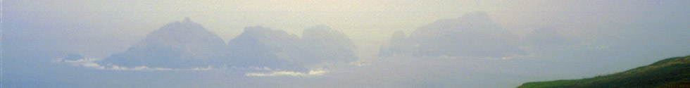
First view of the cliffs at the Herma Ness Nature Reserve, through the mist and rain.
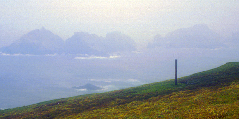 |
My best view of Muckle Flugga in 2005. There's a lighthouse on there somewhere. How they got the materials onto that jagged
rock, I cannot imagine. A rock called the Out Stack, not far beyond but lost in the haze, is the northernmost outcrop of the UK.
Next
| September | /Octoberrrrrrrrrrrr |
| S | M | T | W | T | F | S |
| 18 | 19 | 20 | 21 | 22 | 23 | 24 |
| 25 | 26 | 27 | 28 | 29 | 30 | 1 |
| 2 | 3 | 4 | 5 | 6 | 7 | 8 |
| 9 | 10 | 11 | 12 | 13 | 14 | 15 |
| 16 | 17 |
The North Atlantic Arc Home
Mr Tattie Heid's Mileage
Results may vary
MrTattieHeid1954@gmail.com