from Holy Island to the Isle of Iona

3 October 2010
The North Atlantic Arc Home
| September | /October/ | November |
| S | M | T | W | T | F | S |
| 27 | 28 | 29 | 30 | 1 | 2 | |
| 3 | 4 | 5 | 6 | 7 | 8 | 9 |
| 10 | 11 | 12 | 13 | 14 | 15 | 16 |
| 17 | 18 | 19 | 20 | 21 | 22 | 23 |
| 24 | 25 | 26 | 27 | 28 | 29 | 30 |
| 31 | 1 |
 |
|
9 September 1513--Henry VIII's England is at war with France. In support of the Auld Alliance, Scotland joins the fray.
King James IV himself leads his army south. On Branxton Hill, the Scots await the small English force left to guard the north.
Unexpectedly, the English approach from the opposite side of the hill, and the Scots rush to redeploy. They hold the higher ground,
but have no way to take advantage of it--their heavy guns, hastily repositioned, fire over the heads of the English. The lighter
English artillery is more maneuverable and more accurate.
The Scots' left line charges down the hill to engage the enemy. They are armed with fifteen-foot-long pikes, which they use to great effect. The English are nearly routed, saved only by a cavalry charge. Encouraged by that success, James leads his center down the slope. The Scots greatly outnumber the English and are brimming with confidence. The low ground here, which they have not scouted, is marshy, made all the wetter by the preceding weeks of rain. They are quickly bogged down, losing the tight formation that makes the pikes effective. The English are armed with bills, devastating in close combat. In short order James and 10,000 of his men, including a large part of Scottish nobility, are dead. The English are too preoccupied with France to press their advantage with Scotland just now, but the Scots will never forget the most brutal military defeat in their history, on the sodden ground of Flodden Field. [Journal continues below] |
 |
Flodden Field
 |
Flodden Field
 |
Down Toward Branxton
|
Sunday 3 October 2010--Rainy morning, and I'm in no hurry to get out of Coldstream. It's after 10:00 when I cross the Tweed once again
into England and drive the few miles to the battlefield on Flodden Field. I'm not really too sure how worthwhile I'm going to find
this, but ultimately it's an evocative experience, following the battlefield trail. Given the history I know, I'm left to think that
the Auld Alliance with France never did Scotland a bit of good.
Yetholm is almost directly south of Coldstream, with a westward protrusion of England between; this is the only place where it's possible to drive south from England into Scotland. Town Yetholm is the larger of twin villages here, but Kirk Yetholm is more charming, and the Border Hotel is the northern terminus of the Pennine Way. I saw the southern terminus in Edale last year. I can only imagine the sense of accomplishment a through-hiker would feel on arriving here. The Border is a very handsome country pub, CAMRA's regional pub of the year two years running. At 12:30, Sunday lunch is in full swing, but I'm still full of breakfast; and it's much too early for a pint. Oh all right, just the one. I have a routing in mind from here, a number of sights to see, but in the dim weather, I abandon that plan and instead go wandering along the back lanes hugging the northern edge of the Cheviot Hills. Stop at the place where Dere Street, the ancient Roman road, descends from the hills on its way from Corbridge. Many parts of Dere Street are now major highways, but the stretch through the hills here is long abandoned. On a whim, I walk up to the low pass between two hills. I'm not sure how closely the track I'm on follows the path of the road, but occasionally square-cut paving stones jut up through the grass. In other places, the feel of the earth beneath my feet gives me the impression that they are not far below the surface. I try to picture what the road would have looked like, with a Roman legion or supply train passing through on the way to the Antonine Wall, during the brief period when that constituted the far-flung edge of the empire. Imagination fails me. At the top of the rise, I look out over a stone-walled sheep pasture into wild land, tracked only by sheep and, I suppose, their herders. (Well, the Pennine Way is over there somewhere, too.) Driving these remote roads, and now looking down into this uninhabited valley, I gain a new appreciation of what the Borderlands have always been about. England's far, remote north, and Scotland's far, remote south, they are a maze of hills and dales well-suited for cattle thieves and reivers. The Ordnance Survey map shows a hillfort near here, and I'm guessing it's on the slope to my right, which the map labels Woden Law. Is that local dialect for "wooded", or reference to the Germanic god? Whatever the case, I trudge up and hit the jackpot--there are at least four concentric rings of earthworks circling the hilltop. A few stones here and there hint at other structures, and I wonder whether the Romans made use of this spot, perhaps for a signal tower. None of the stones I see have that telltale square cut. Back down, I can see that the path of Dere Street coincides briefly with the modern road. There is a ford just down from where I've parked, and I drive down meaning to cross. It's been raining, though, and the crossing looks as though it might be just a little too deep for my tiny rented Skoda. Fortunately there is an alternate route. I take the back roads into Denholm, where I'm staying tonight. The sky clears to the west, and beautiful golden light bathes the pastoral dales I'm driving along; could have used that when I had time to stop and take photos. Soon enough I am in the Auld Cross Keys having dinner and a pint, alternately amused and appalled by the gamboling of a gaggle of feral children in the lounge. Their parents have neglected to bring along the border collie that would have kept them herded quietly in a corner of the room. Next |
 |
The Border Hotel
 |
The Border Hotel
 |
You Have Been Warned
 |
Dere Street
 |
Dere Street
 |
Woden Law
 |
Borderlands
 |
Borderlands
 |
Borderlands
 |
Woden Law
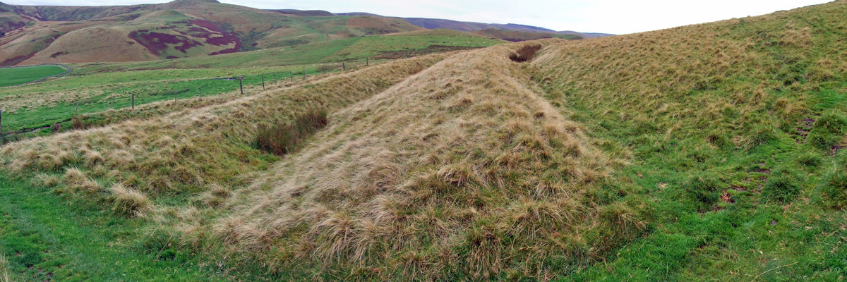 |
Woden Law
 |
But I have a Skoda
 |
Ford Trumps Skoda
Next
| September | /October/ | November |
| S | M | T | W | T | F | S |
| 27 | 28 | 29 | 30 | 1 | 2 | |
| 3 | 4 | 5 | 6 | 7 | 8 | 9 |
| 10 | 11 | 12 | 13 | 14 | 15 | 16 |
| 17 | 18 | 19 | 20 | 21 | 22 | 23 |
| 24 | 25 | 26 | 27 | 28 | 29 | 30 |
| 31 | 1 |
The North Atlantic Arc Home
Mr Tattie Heid's Mileage
Results may vary